|
In 1853, the writer John Phillips
observed that, looking north from Bentham, one sees "Several
elevated fells, which in grandeur and variety of interest are
second to few in the kingdom. These are Whernside (anciently
Quernside); Ingleborough, the fire or beacon mountain; and Penyghent,
or in Celtic Penygwynt, the Head of
the Winds. These three peaks shine with a mild glory over magnificent
scars of limestone, penetrated by numerous and beautiful caverns,
and give birth to sparkling waters which enliven the greenest
of valleys. They are fondly imagined by rustics to be the highest
mountains in England. On Jeffrey's excellent map [1775] Ingleborough
is said to be a mile high"

Limestone
forming, 350,000,000 years ago
Phillips continues: "These hills are easy of access
from a country full of comforts; where pedestrians and equestrians
will find plentiful establishments for feeding man and horse.
Yet how few Yorkshiremen who glory in their County have ever
set foot on Ingleborough!" Although his remarks about local
refreshments still ring true, Ingleborough has long since been
discovered by walkers from near and far, and the scars of their
boots on the mountain's summit are visible from here. However
the damage is only skin-deep.
The summit of Ingleborough is a thick
flat cap of millstone grit which has survived Ice Ages and Dales
weather alike all these years, and will probably continue to
do so. Below the cap you can see buttresses and bare "scars"
of the Yoredale limestone series, and
these are supported on huge cliffs of Silurian strata. These
oldest (Ordovician, slate) layers are vertical, upheaved by some
geological cataclysm 400m. years ago, roughly. The join of slate
and limestone is called the Unconformity.
|
Bentham, blessed by rich soils
deposited by the Wenning, and well-watered by westerly winds,
lies at the crossroads of a fascinating landscape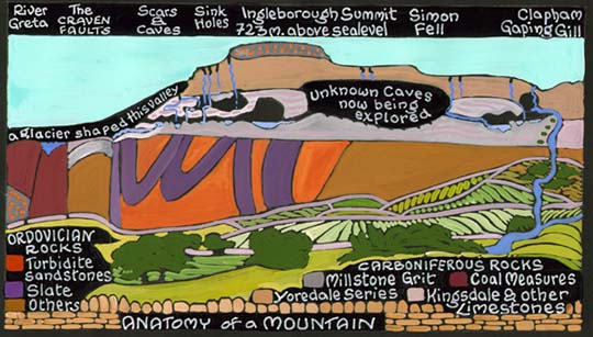
By 350,000,000 years ago, the Dales
area was a warm shallow sea with coral reefs. The proof is in
the limestone - which is just the fossil remains of the shells
of the small sea-creatures who lived here for a very long time.
Then the millstone grit layers formed above, from coarse blown
sand. And then the Ice Ages arrived, with glaciers, carving out
the valleys. Climate change is not a new phenomenon.

During a warm spell between the
Ice Ages, 130,000 years ago, hippos and elephants wallowed in
the Wenning.
When the glaciers retreated, around 25,000 years ago, they left
behind mounds of pebbles - terminal moraines, or "drumlins".
These form the smaller, rounded hills of Wenningdale. Some have
been excavated, as at Cowslip Hill. They also left many "Erratics"
behind, boulders dropped at random. The Big Stone may be an erratic,
but there is some controversy. It is the "Great Stone of
Fourstones", but what happened to the other three? It's
a mystery. Here's another. If you look round the back (south
side) you'll see some even older steps.....
|
Southward, the Trough of Bowland is a
very different landscape, based on sand-stones and shales, and
"provides numerous features of spacious dignity." From
here one may drive the 25 miles to
Clitheroe through real wilderness and encounter only three small
villages - an experience of "spacious dignity" almost
unique in populous England. Westward lies the "Aire Gap",
the principal route over the Pennines. Eastward, Lunesdale opens
out onto the Irish Sea a mere 15 miles away, which contributes
further to our local abundance of fresh air. 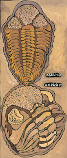
Silurian
Strawberry-headed trilobites - 400,000,000 years ago. |